I decided to test out Copilot on another MapRun-related challenge: planning the optimal route for a score event. Our Summer League events are, more often than not, planned using OpenOrienteeringMap. This uses OpenStreetMap data for the base map. The format is usually a 45-minute urban score event, using MapRun’s ScoreNxx scoring system. The aim was to take the KML file that describes an event, and determine the best route to take to maximise the score. As a constraint, I would specify the maximum distance that the route should cover (i.e., how fast the competitor was expected to run).
(more…)Author Archive
MapRun Score Optimal Route Planning
Sunday, October 5th, 2025Summer Orienteering in Slovenia and Italy
Saturday, August 16th, 2025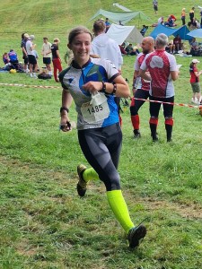
We decided to spurn the Scottish 6-Days for our orienteering holiday this year, and instead went south to the OOcup. The event moves around, but this year was taking place on the Slovenia/Italy border. We flew Easyjet to Venice and then hired a car to drive the 200km to Kranjska Gora where we had rented an apartment. (I now know much more about cross-border hire charges than I ever wanted to. For the record, Enterprise was around £25 for the week.)
(more…)MapRun League Results Generator
Saturday, August 2nd, 2025Southampton Orienteering Club has what is now an annual MapRun league. A few years ago, I wrote a tool to scrape the results for each event, allocate points (only your first attempt counts, and it must be in a specific time window), and publish some HTML results. For example, those from this year (which I might just happen to have won!). For some reason lost in the mists of time, it was written in Node, but I decided that I would rewrite it in Golang before sharing it with the world on GitHub.
(more…)Dartmoor DofE
Saturday, July 26th, 2025
Duncan’s Silver Duke of Edinburgh expedition was on Dartmoor, and I was on the hook for driving half the group down early on Saturday morning, and back on Monday. It seemed to make sense to stay down there and make a long weekend of it.
The journey there was remarkably painless, and once they’d been briefed by the leaders, they set off north from Bennett’s Cross. I was due to meet my uncle in Bovey Tracey for lunch, but had time for a quick circular walk past Grimspound. In addition to the obligatory Dartmoor ponies, I also spotted a fox and some llamas (the latter captive!).
(more…)Creating a Membership List in Drupal 11 with Aggregating Views
Wednesday, July 9th, 2025I’ve written before about our use of Drupal for the Southampton Orienteering Club website. We’re now on Drupal 11, and my opinions haven’t really changed. Upgrades are still painful, particularly the community modules that we have to leave behind each time. The user experience for creating content also lags behind newer alternatives. We have a significant amount of historical content on the site (not all of it publicly visible), making a move a daunting proposition. In the meantime, as this post demonstrates, we continue to utilise the powerful features that Drupal and its ecosystem offer.
(more…)Stopping the Git CredentialHelperSelector from popping up
Tuesday, June 24th, 2025Recently, I was plagued by the “CredentialHelperSelector” dialogue popping up multiple times when attempting to pull from a remote Git repository. This was despite repeatedly selecting the option to remember my selection to use manager and various attempts to explicitly set the config helper via the command line.
Updating the symbol set and magentic north with OpenOrienteering Mapper
Sunday, June 15th, 2025
I spend a couple of hours a week hanging around the leisure centre at Fleming Park while Emma swims. For the past month or so, I’ve been using that time to update the orienteering map of the area, ready for the SOC Summer Series event there in August. The fairways of the old golf course are becoming increasingly overgrown, aided by the planting of lots of new trees. I therefore wanted to update the map to the latest sprint specification, ISSprOM 2019-2, so that I could make use of the ‘rough open with scattered bushes’ symbol. Although it hasn’t shifted much since 2016, I thought it was also time to update magnetic north.
The following directions for OpenOrienteering Mapper (OOM) are based on those I received from the club’s mapping officer, Mark Light.
(more…)Helm: for better or worse?
Monday, June 9th, 2025A few weeks ago, one of my colleagues at JUXT gave a presentation on Helm, and this started me thinking back over my own experiences with the tool. It appears I already had a lot to say on the subject back in 2018! Since then, I’ve made extensive use of Helm at CloudBees where we had an umbrella chart to deploy the entire SaaS platform, and at R3. It’s that latter experience that I’m going to talk about in this post.
(more…) RSS - Posts